A certain panel depicting a very European-looking face at the Brihadeeswara Temple in Thanjavur has puzzled devotees for years. Now, many historians believe the sculpture is of the extraordinary cartographer and soldier Lt. Col. William Lambton.
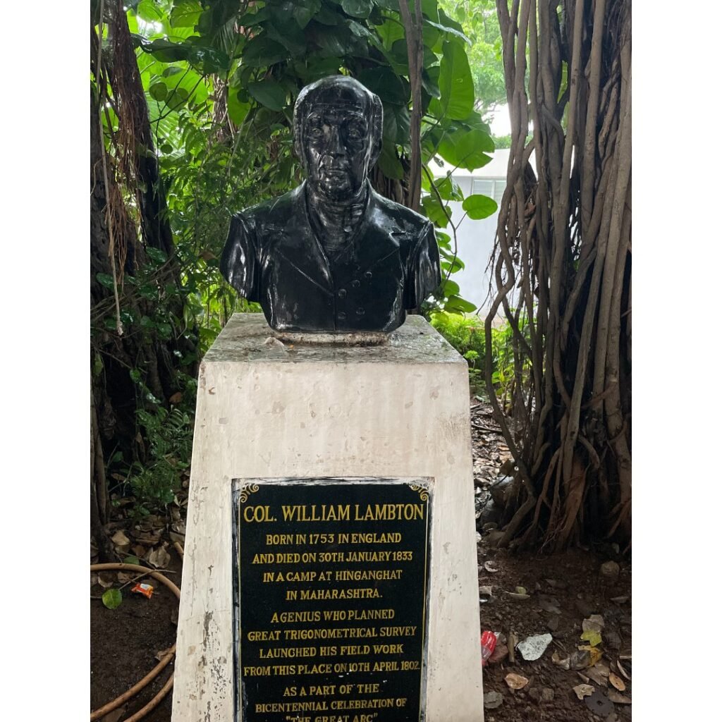
No one knows when exactly Lambton was born; our best guess is 1753. Young Lambton had a passion for science, especially mathematics and astronomy. Once he damaged one of his eyes trying to observe a solar eclipse with inadequate protection!
When he grew up, Lambton started working as a surveyor for the British army in America. He was taken prisoner in the Battle of Yorktown (1781) but was released after the American War of Independence. In 1796, he was posted to India, where he took part in many campaigns. It was during the Fourth Anglo-Mysore War that his navigational skills came to the fore. The most celebrated case was when General Baird led the troops on a night manoeuvre: without realising it, he began leading them towards enemy lines. Lambton, navigating by the stars, corrected the general, and prevented slaughter by enemy cannon.
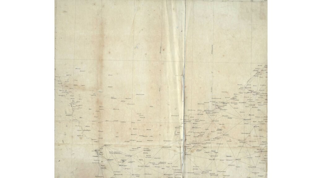
After the fall of Mysore, British India had become a large colony. Lambton proposed a survey to map this territory accurately. There was administrative, security and commercial justification for Lambton’s idea, because maps of those days were very approximate. There were some reservations in the beginning – some of the higher authorities were not convinced about the project’s significance. Ultimately, Maj. Gen Arthur Wellesley (later the Duke of Wellington) and some other influential leaders backed Lambton, and that was how Lambton began the Great Trigonometrical Survey of India in 1802.
By this time, trigonometry (Greek for ‘triangle measurement’) was a mature science. Lambton used a trigonometric method called triangulation. Its principle was: if you know the distance between two points in a line (the baseline), you can calculate the distance to a third point without actually measuring it; all you need to know is the angles between the two baseline points and the third point. These three points would form a triangle and a trigonometric formula would do the trick! After that, you kept adding adjacent triangles till you measured the whole land.
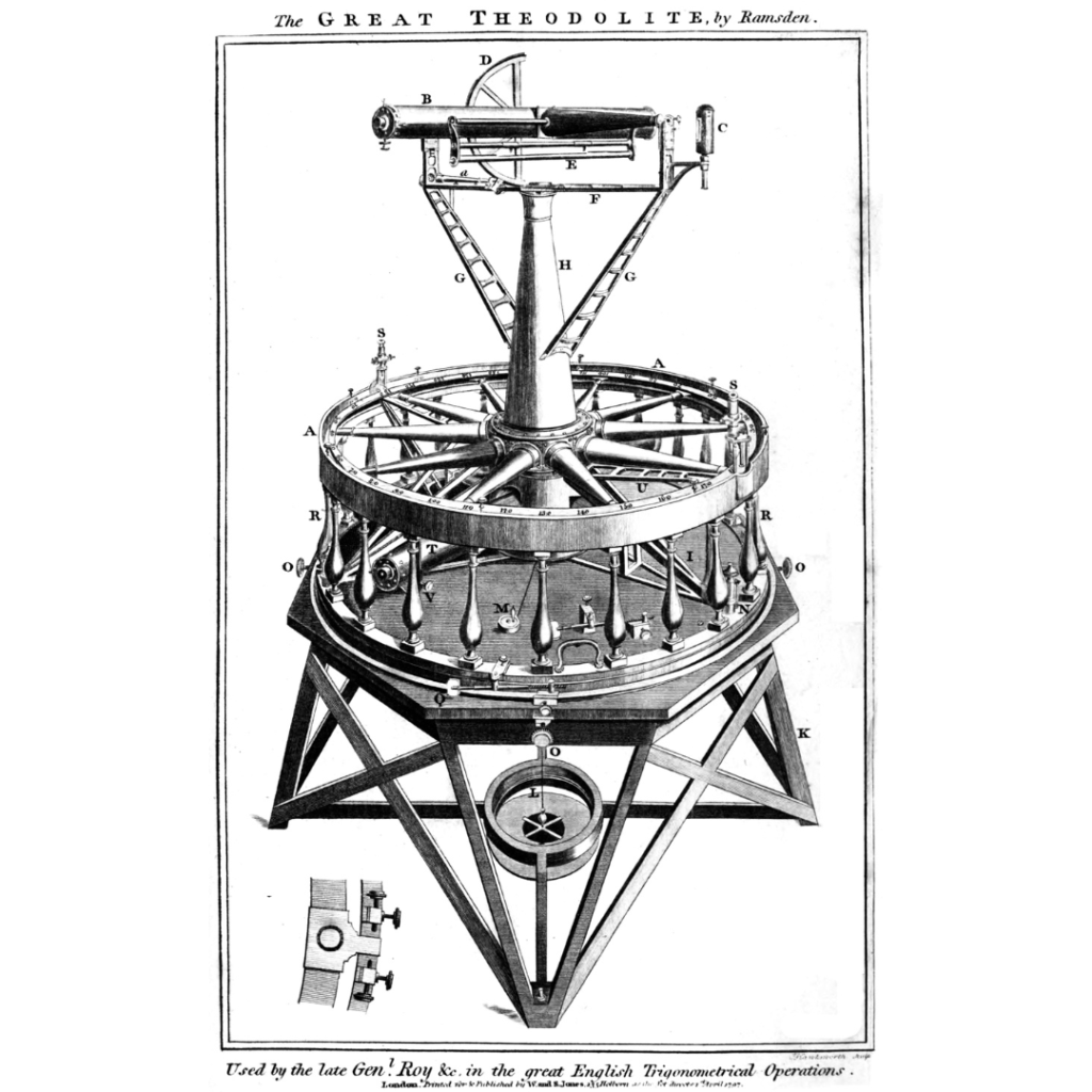
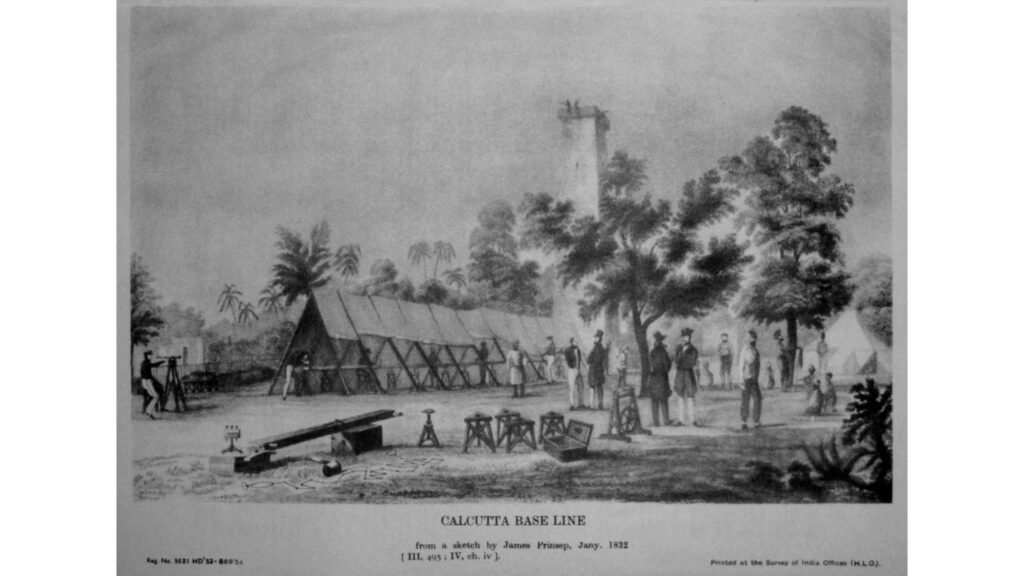
The first baseline of the survey was between Marina Beach and the Madras race course (roughly 12 kms away) and the observation post was St. Thomas Mount in Chennai. The actual work was deceptively simple. The distance was measured with a blistered steel chain (which was less prone to thermal expansion) exactly 100 feet long at 62 0 F. They carried a thermometer with them, so that they reworked the length if the temperature was different (the correction was +/- 0.00725 inches for every degree Fahrenheit variation). The angles were calculated using a device called theodolite – it weighed over half a tonne and was carried by 12 men.
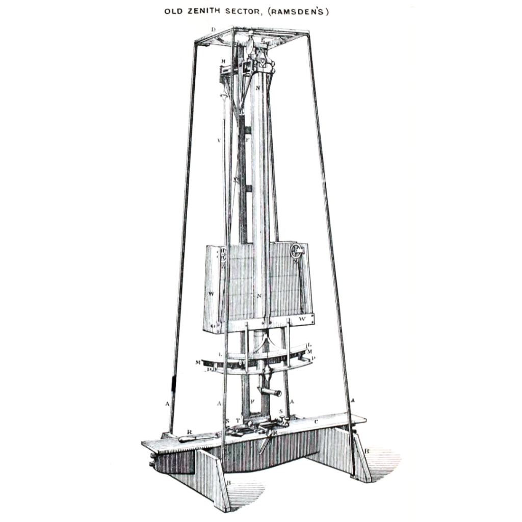
And he used another instrument called the zenith sector which pinpointed the location with reference to the stars. Because the Earth is not a flat plane, they had to make many daily adjustments in the readings to compensate for this; these were factors like the curvature of the earth, its non-spherical nature, altitude and its effect on gravity (they used pendulums and plumblines), refraction errors, temperature variations and so on. It was a laboriously slow process for the survey party of about 150 men. Accuracy, not speed, was the focus.
The survey team crossed rivers, mountains, and jungles, braving rain, wild animals, thieves and disease, across the peninsula. Four years later they arrived at Mangalore, on the west coast. Lambton’s map proved that Mangalore was closer to Madras by a whopping 10% as compared to the previous official figure! The East India Company was greatly impressed. They now wanted India to be mapped from Kanyakumari to Banog in the Himalayan foothills! It was much longer than the five-year project that they had originally planned for. Lambton immediately began the southern phase from Kanyakumari to Nagpur.
It was then that the survey team reached Thanjavur. The team needed a high point for the survey and got permission to perch on top of the Brihadeeswara temple gopuram (tower). At 65 metres, it was one of the tallest structures in India then.
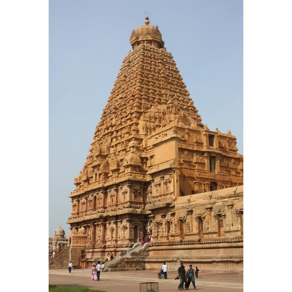
They hauled the massive theodolite up the tower. Unfortunately, a mishap occurred – they accidentally dropped the theodolite from the gopuram while setting it up. That was a big setback, but Lambton salvaged it carefully. However, the theodolite had also chipped off a part of the bas-relief on the tower. Now, this was a holy temple and Lambton was obliged to repair it immediately. Apparently they affixed a new image – a modern Lambton look-alike. There is no clear evidence on how it was executed. Perhaps they got away with it because the then Thanjavur king – Serfoji II – was a British ally and a progressive sponsor of scientific knowledge.
Not all kings were friendly though. Lambton had to cross several other Indian princely states in his route during the survey. Some of them panicked when they saw the military-looking team entering their borders. (At its peak the survey team had nearly 700 members!) Only after they patiently explained the project did the kings support the scientific exercise.
Once, the French navy intercepted a ship carrying Lambton’s theodolite and seized it, probably assuming it was a weapon. When they understood its purpose, they gracefully repacked it and returned it to him. Sometime in 1817, a membership in the French Academy of Sciences was conferred upon Lambton!
The project moved on. If Lambton was constantly on the move, what kind of family life did he have? We can only guess. Apparently, for many years, he sent a substantial portion of his salary back home, to support his parents; therefore, raising his own family might have been financially challenging. And he was married to this project. But somewhere along the way, he found himself an Indian companion named Kumerboo and had at least three children with her. One of them – William Lambton Jr.—joined his father’s survey team in 1815.
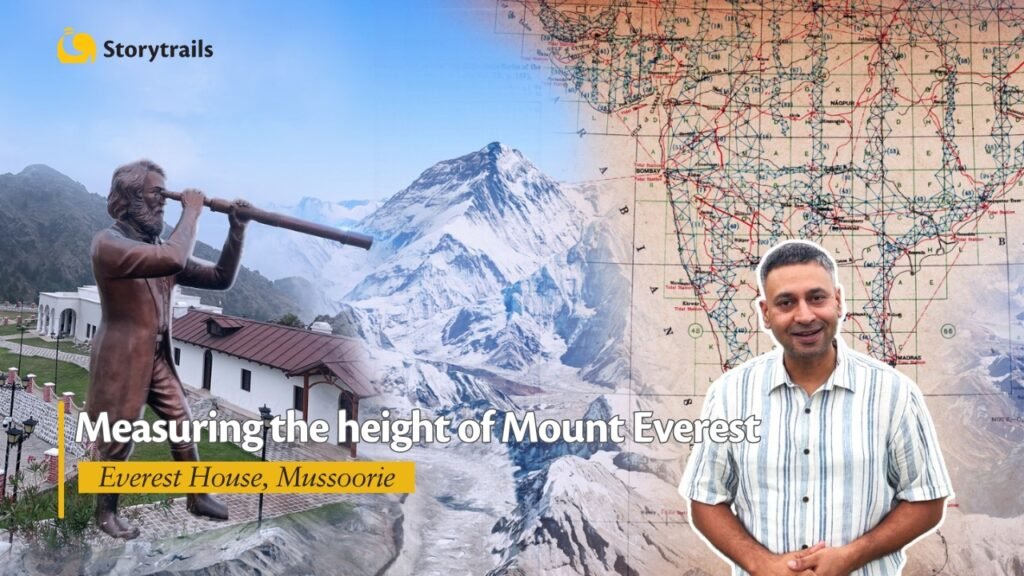
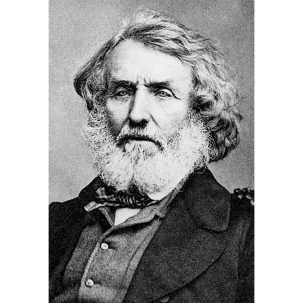
For Lambton, 1818 was an eventful year. He was invited to become a Fellow of the Royal Society. Governor-General Warren Hastings realised the national importance of the survey and made it a central subject under the control of the Supreme Council at Calcutta (now Kolkata). Lambton had triggered a culture of scientific cartography in India! His survey was formally christened the Great Trigonometrical Survey (GTS) and he became its first Superintendent. He was also allotted an energetic deputy – Captain George Everest. Years after Lambton died and Everest had retired, the GTS ascertained that peak XV in Nepal was the tallest peak ever. It was named after Everest, the worthy successor of Lambton.
Sir Isaac Newton had theorised that the Earth was not a sphere but an oblate spheroid. An oblate spheroid is something like grapefruit – nearly spherical but flattened at the top and bottom. Newton had concluded that this shape is caused by the spinning of the Earth. Lambton’s expedition had covered such a large portion of the Earth, that it created adequate field data to support Newton’s theory. Lambton’s work was thus very important in the scientific world.
By late 1822, Lambton was approaching Nagpur, the end of the southern phase. He had covered around 4,25,000 sq.km in about 20 years, mostly by foot. A sturdy man, he was suddenly struck with pulmonary illness. He was around 70, but still vigorous. He recovered and got ready for the final trek to Nagpur, 75 kms away. But he never saw Nagpur. He passed away peacefully in his sleep at one of the camps.
But his team never faltered; they crossed Nagpur and eventually reached the Himalayas many years later. Perhaps the greatest manual survey in the history of science, the Great Trigonometrical Survey functioned for about 70 years, led by successors who practised Lambton’s high standards. In 1875, it merged with the Survey of India and became a permanent department of the government of India.